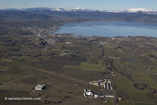
 This aerial photograph of Lampson Field airport, Lakeport, Lake County, California is part of an extensive collection of current and historical aerial photographs of Lampson Field, Lakeport, California and Lake County available from Aerial Archives. This aerial photograph shows a view of Lampson Field airport (102) toward the city of Lakeport and Clear Lake during the winter. North of Lakeport in the background are the mountains of the Mendocino National Forest, including, in the center background, Snow Mountain, part of the Snow Mountain Wilderness. The summit of East Snow Mountain has an elevation of 7056′, the highest elevation in Lake County. Lampson Field is a public airport owned and operated by Lake County, located 3 miles south of the town of Lakeport. The airport covers 68 acres, has one runway (28/10), features a 4 degree glide path 2 light, precision approach path indicator lighting system (PAPI), an automated weather observing system (AWOS) and a pilot controlled lighting system. The field elevation is 1380′ (420.7 meters). The runway is asphalt, 3600′ long and 60′ wide. The CTAF/UNICOM frequency is 122.8, and AWOS-3 is available on 118.35 or by dialing 707.262.0380. As of the year ending December 31, 2017, the airport had an average of 209 operations per day. Among the businesses on the field are Tom’s Aircraft Enterprises, which provides aircraft repair and maintenance services and annual inspections, Steve’s Aircraft Repair, which specializes in major aircraft structural repair and LASAR, an aircraft repair shop that specializes in Mooney aircraft and is a Mooney parts dealer. REACH Air Medical Services has a operational base at the airport and bases a helicopter at the field. 100LL fuel is available via a self serve fuel island. A published RNAV (GPS) instrument approach is available for Lampson Field. Lampson Field was opened as a public airport in 1941.
Image ID: AHLE0379
© Herb Lingl/aerialarchives.com
License this photograph or purchase a print.
More aerial photography of Lampson Field airport.
More aerial photography of Lake County, California.
