Herb Lingl

Aerial Photographs of Big Sur Landslides

aerial photograph of repair of Highway 1, Big Sur, Monterey County, California after a landslide
This aerial photograph of shows the repair of Highway 1, Big Sur, Monterey County, California after a landslide in 2021.
Image ID: AHLE0980
© Herb Lingl/aerialarchives.com

Aerial photographs of Big Sur landslides are invaluable in monitoring erosion along Highway One and in planning repairs.

Landslides have caused the collapse of portions of Highway One along Big Sur numerous times.

Highway One, officially known as California State Route 1, is a major north south highway most of which runs along the Pacific coastline. It’s the longest state highway in California and is over 650 long from its southern terminus near Dana Point in Orange County to its northern terminus near Leggett in Mendocino County.

Highway One was built in various pieces. The first section opened in the Big Sur area in the 1930s. Highway One in the Big Sur region covers a little over 70 miles from San Carpóforo Creek to Malpaso Creek.

Much of the highway winds along the cliffs of the Santa Lucia Mountains and passes over bridges. Notable Highway One bridges in the Big Sur region include the Bixby Creek Bridge, the Big Creek Bridge and the Rocky Creek Bridge.

Big Sur is a scenic, rugged and mountainous part of the California Central Coast where the Santa Lucia Mountains meet the Pacific Ocean. It is protected by the Big Sur Local Coastal Plan which was approved in the 1980s. The plan places extensive restrictions on development and population density. In addition, about 60% of the coastal region is owned by either private parties or government entities which prohibit development.

Before the construction of Highway One, Big Sur was one of the most remote parts of California.

Erosion and landslides affect various portions of Highway One along the California coast, but they are more frequent in the Big Sur area.

Highway One in the Big Sur area has been closed over 50 times because of land and mud slides.

Aerial photographs of these Big Sur landslides have been critical to highway repairs and erosion analysis.

License this photograph or purchase a print

More aerial photographs of Big Sur

More aerial photographs of Monterey County, California

Aerial photographs of erosion

Share

Aerial Photographs of San Francisco Bay Salt Ponds

aerial photograph of a red salt evaporating pond in San Francisco bay
This aerial photograph of a red salt evaporating pond in Newark, California shows a pond in the San Francisco Bay salt pond network with intense colors resulting from Halobacteria, Duniella and tiny brine shrimp.
Image ID: AHLB2957
© Herb Lingl/aerialarchives.com

Aerial photographs show the vibrant colors of San Francisco Bay salt ponds better than any view from the ground.

The colors of the ponds range from bright reds, to green, yellow and brown. The colors depend primarily on the salinity of the pond.

The Ohlone were already producing salt in San Francisco Bay when Spanish explorers arrived.

Industrial production began in the 1850s. At that time, numerous small family operations created salt ponds from wetlands in Redwood City, Newark, Hayward and other portions of San Francisco Bay. Over the years, those small businesses were replaced by several companies. Eventually Cargill purchased these companies and built a network of salt ponds that covered over 16,000 acres.

In order to restore salt ponds back into wetlands, Cargill sold most of its San Francisco Bay salt pond holdings to the California Coastal Conservancy, the United States Fish and Wildlife Service, and private foundations in 2003. The project, known as the South Bay Salt Pond Restoration Project, is the largest wetland restoration project on the West Coast of the United States.

Aerial Archives’ collection of aerial photographs of San Francisco Bay salt ponds includes aerial overviews of the entire network of salt ponds and numerous detailed aerial views.

License this photograph or purchase a print

More aerial photographs of salt ponds

Details about salt pond aerial photography

Aerial photographs of wetlands

Aerial photographs of San Francisco Bay

Share

Aerial Photographs of Natural Gas Flares in Wyoming

aerial photograph of natural gas flare Wyoming
This aerial photograph shows a flare stack burning natural gas in southern Wyoming. It illustrates the large amount of black carbon that can be released into the atmosphere by some flares.Flaring has increased significantly in the United States in recent years. According to the World Bank, flaring in the US increased 48% between 2017 and 2018. Fracking has resulted in the production of large amounts of natural gas along with oil production. With the oversupply of natural gas, some operators are flaring gas. A study published in Atmospheric Chemistry and Physics indicates that gas flares have contributed to over 40% of the black carbon deposited in the Arctic. Black carbon deposits contribute to the rates of snow and ice melt. Flaring also contributes substantially to the amount of CO2 emitted into the atmosphere and is an important contributor to global warming. Properly operated flares convert methane to CO2. Methane’s global warming impact is 34 times greater than that of CO2. Improperly operated flares may emit methane, sulfur dioxide and a variety of carcinogenic hydrocarbons. There are more natural gas flares in the United States at this time than any other portion of the globe. Both satellite imagery and aerial photography are useful tools to identify the location and density of natural gas flares.
Image ID: AHLB9621
© Herb Lingl/aerialarchives.com

License this photograph or purchase a print.

More aerial photographs of gas flares.

More aerial photography of the oil and gas industry.

Information about aerial photography of the oil and gas industry.

More aerial photographs of the Wyoming.

Share

Aerial Photography of Napa Valley in the Spring

aerial photograph of Napa Valley in spring
This aerial photograph of Napa Valley in the spring shows a view of California Highway 29 toward Mount Saint Helena.
Image ID: AHLB4117
© Herb Lingl/aerialarchives.com

The yellow areas visible in this aerial photograph of Napa Valley are blooming mustard fields. Numerous vineyards in Napa Valley plant mustard. Mustard serves as a bio-fumigator that suppresses pests and diseases. It is also rich in nitrogen and has long been used as a cover crop.

The Oakville AVA is in the foreground of this aerial photograph. The AVA is known for its success with Bordeaux varietals. It extends from the Mayacamas mountains on the west to the Vaca mountains on the east. Over 50 wineries source their grapes from vineyards in the Oakville AVA. The AVA covers approximately 5000 acres of planted vineyards.

The tracks of the Napa Valley Wine train which run along highway 29 are visible in the photograph.

The Opus and Mondavi wineries are located slightly above the middle ground of the photograph. Trees growing along the Napa River show the course of the river beginning in the middle ground right of the photograph.

License this photograph or purchase a print.

More aerial photographs of the Napa Valley.

More aerial photography of vineyards.

More information about aerial photography of the Napa Valley.

Share

Aerial Photographs of Olympic Park in Montreal

=" Olympic Park, Montreal, Quebec, Canada viewed from across the Saint Lawrence river
Aerial photograph of Olympic Park (Parc Olympique), Montreal, Quebec, Canada, home to the 1976 Summer Olympics as viewed from Longueuil across the Saint Lawrence river.
Image ID: AHLB4150
© Herb Lingl/aerialarchives.com

Numerous aerial photographs of Olympic Park and the Olympic Stadium (Stade Olympique) in Montreal are available from Aerial Archives. The Olympic Stadium is a multi purpose stadium with the largest seating capacity of any stadium in Canada. It was designed by French architect Roger Taillibert.

The design incorporated a retractable roof opened and closed by cables suspended from the 175-meter (574 ft) Olympic Tower. The Olympic Tower is the tallest inclined structure in the world.

The Olympic Tower includes a multi-story observatory which opened in 1987. It’s accessible via an elevator that can carry up to 76 people per trip. Panoramic views available to elevator passengers include views of the Olympic Village, and the Botanical Gardens.

One of the twin Olympic Village structures is at right. The Olympic Village towers housed all of the 1976 summer Olympics athletes except the sailors and equestrian competitors. The Olympic Village was designed by architects Roger D’Astous and Luc Durand.

Maisonneuve Park, Montreal Botanical Garden and Montreal Insectarium are visible in the background of this aerial photograph.

Additional aerial photographs Olympic Park in Montreal include detailed views of the Olympic Tower and Olympic Stadium.

License this photograph or purchase a print.

More aerial photographs of Montreal.

Description of the collection of aerial photography of Montreal.

Description de la collection de photographies aériennes de Montréal.

Share

Free Airplane Rides For Kids Ages 8-17 at Lampson Field, Lakeport, CA

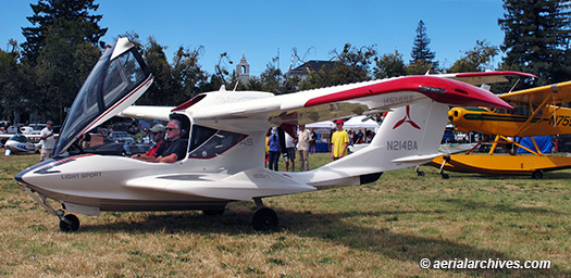
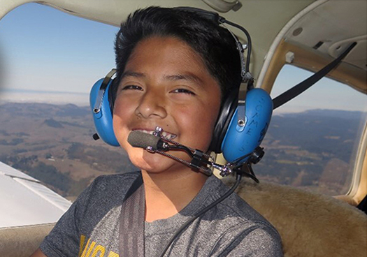
The Lake County Chamber of Commerce and Chapter 124 of the Experimental Aircraft Association (EAA) based at the Charles M. Schulz – Sonoma County Airport are teaming up to raise awareness of outstanding career opportunities for young people in aviation. The centerpiece of the effort will be free flights for young people at Lampson Field airport in Lakeport, CA on Saturday, November 23 provided by EAA Chapter 124 as part of the EAA’s Young Eagles Program. Any interested individuals between the ages of 8-17 are invited to participate in this EAA Young Eagles rally.

Registration for the event by young people aged 8-17 has been strong.

There are currently 12 pilots providing free flights scheduled for 54 young people, with another 58 young people on the waiting list. Volunteer pilots are a diverse group that includes a senior aviation executive and flight instructor, a practicing attorney, a retired airline pilot, aircraft builders and an aerial photographer.

Volunteer pilots provide the free rides in their own aircraft as part of an EAA program that has provided free rides to over 2 million young people. Among the aircraft that volunteer pilot owners are making available for the event are a Cessna 340, a Cessna 195, a Mooney, a Piper Arrow, an Aeronca Champ, a Taylorcraft, an RV6 and an RV12.

The Lake County Chamber of Commerce and EAA Chapter 124 organized the event as part of an effort to make members of the Lake County community aware of the outstanding career opportunities for young people in aviation. In addition, participants will learn about opportunities for Lake County high schools to obtain a high quality aviation curriculum developed by the Aircraft Owners and Pilots Association (AOPA) at no cost.

Unlike many fields where jobs are disappearing, career prospects in aviation are bright. Boeing’s CEO, Dennis Muilinberg noted at the Paris Air Show in July, 2019 that there will be a need for 800,000 new pilots in the next 20 years, and that there will be a severe pilot shortage. Each of the major US airlines has already begun investing capital to deal with this shortage.

As Lake County Chamber of Commerce CEO Melissa Fulton notes that “It’s important that students and parents in Lake County become aware of the career opportunities in aviation, including jobs as aviation mechanics, avionics technicians, corporate, airline and military pilots and aerial photographers.”

The Young Eagles rally begins at 9 am in the hangar of LASAR (Lake Aero Styling and Repair). LASAR is one of the world’s largest Mooney Service Centers.

LASAR is located at:

900 F Sky Park Dr.
Lakeport, CA 95453

During the rally, pilot John Swanstrom, a member of EAA Chapter 124, will present his visually dynamic seminar about the basic principles of flight and aviation. The ground school also includes a presentation entitled Career Opportunities in Aviation, an overview for students and parents produced by Clear Lake Flying Club director of education Herb Lingl.

A number of aviation professionals will be available to answer questions about careers in aviation that the young people and their parents may have. These include, in addition to the aviation professionals providing rides in their aircraft, employees of REACH Air Medical Services, which provides helicopter transportation services from Lampson Field and mechanics and pilots based at Lampson Field, Sonoma County airport and elsewhere, including a retired United Airlines mechanic that spent 35 years working for the airline.

The Clearlake Modelers will also have on display a number of model aircraft. Members of the model aviation flying club will be available to answer questions about their aircraft and how to become involved in flying model aircraft. Building and flying model aircraft is a great way for young people to learn more about aviation.

After receiving their ground briefing, participants will be assigned to an aircraft and take their FREE aircraft flight! Afterwards, participants will receive a certificate and a starter logbook to record their flight time.

“Ín addition to getting young people excited about flying and about the career opportunities in aviation, we hope the event will help us identify individuals who might be interested in teaching the AOPA curriculum”, says Lingl. The members of the Lake County Chamber of Commerce are working with Lake County schools to encourage them to submit applications to AOPA to teach the curriculum in the coming 2020/2021 school year.

To register for a November 23 Young Eagles Flight (wait list only available at this time, but even if you don’t get a flight this time you’ll get an invite to our future events) please visit:

Register for a Free Flight.

To learn more about Lampson Field airport, please visit:

Lampson Field.

To learn more about the AOPA High School Curriculum please visit:

AOPA High School Curriculum.

To learn more about the EAA Young Eagles program, please visit:

Young Eagles Flights.

A pdf file to help promote the event is available for download at:

Young Eagles Rally Poster.

A pdf file in Spanish to help promote the event is available for download at:

Águilas Jóvenes.

If you are interested in teaching the AOPA High School Curriculum or donating aviation related items for use by the Clear Lake Flying Club for its youth initiative, please visit:

Clear Lake Flying Club Youth Initiative.

The participation of businesses, trade organizations and local government has been essential to producing this event.

Participating organizations providing resources for the event include:
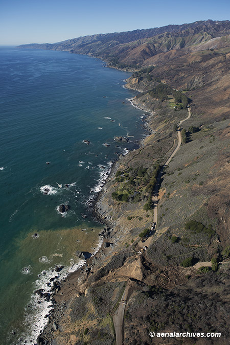
Aerial Archives,
the Aircraft Owners and Pilots Association,
the Clear Lake Flying Club,
the Clearlake Modelers,
the Experimental Aircraft Association,
EAA Chapter 124,
the Lake County Airmans Association,
the Lake County Chamber of Commerce,
the Lake County Office of Education,
the Lake County Department of Public Works,
Lake County Aero Styling and Repair (LASAR),
REACH Air Medical Services,
the Sonoma Jet Center
and Tom’s Aircraft Enterprises.

Share

Clear Lake Splash In Dates For 2020: September 17-20, 2020

ICON Aircraft chief pilot, Rich Bookbinder, demonstrates the ICON A5 amphibious light sport aircraft at the Clear Lake Seaplane Splash In, Lakeport, Lake County, California
Image ID: AHLC3945
© Herb Lingl/aerialarchives.com

The 41st annual Clear Lake Splash In is scheduled to take place from Thursday, September 17, through Sunday, September 20, 2020 in Lakeport, California.

The Clear Lake Splash In carries on the long tradition of seaplane operations at Clear Lake.

The Pan American Airlines Clipper flying boats which operated a Trans Pacific service in the 1920s and 1930s used Clear Lake as a back up landing location when the San Francisco Bay Area was too foggy for operations into the the Pan American seaplane harbor at Treasure Island. The Pan Am Clear Lake ramp was in Lakeport not far from the location of the Splash In.

Over the years, the Clear Lake Splash In has evolved into the largest seaplane fly-in event in the western United States.

The event has hosted a wide variety of seaplanes over the years including some of the largest seaplanes in the world, such as the Grumman Albatross (one year two Albatrosses participated), impeccably restored seaplanes of unique historical significance, rare seaplanes, and some of the latest innovations in the field of seaplane flying.

The event has also featured seminars about aviation and seaplane flying which impart unique information, sometimes difficult to obtain elsewhere.

The 2019 event featured three presentations by Aircraft Owners and Pilots Association (AOPA) ambassador Kay Sundaram.

The seminar entitled Career Opportunities In Aviation outlined the bright opportunities for young people in aviation. The seminar supported efforts by the Lake County Chamber of Commerce and others in northern California to build interest in the adoption of the AOPA High School aviation curriculum by Lake County High schools. AOPA makes this comprehensive curriculum available at no cost to high schools who apply and are accepted to participate in the program.

Kay also presented two other seminars, one entitled Maximum Fun, Minimum Cost: How to Start and Run a Flying Club and You Can Be a Pilot a fast paced, inspiring video presentation for prospective flyers.

As has been the tradition each year, Splash In volunteers provided a free shuttle service between Lampson Field (102), the closest general aviation airport to the event (only 4 miles away), and the Natural High School grounds where the event takes place for those who choose to fly land planes to the event.

Volunteers from the community have been essential to producing this event. In addition, members of community organizations have volunteered to help produce the event. The Lake County chapter of the Sea Scouts, for example, provided ramp safety services. Volunteers from the Lake County Amateur Radio Society provided communication services and shuttle services from Lampson Field.

If you’re interested in this event and would like to participate as a pilot, volunteer or sponsor for the 2020 Clear Lake Splash In, please get in touch. You can use the contact link on the top right of this page or the contacts available at the web pages referenced in the links below.

Areas where volunteers would be invaluable for next year’s event include help with event planning and fund raising, social media, seminar planning and event marketing.

If you’re a seaplane pilot and have ideas for next year’s event, please pass those along.

To view photographs of the 2019 and previous Splash In events, please visit Clear Lake Splash In photographs.

To follow the Clear Lake Splash In on Facebook, please visit Clear Lake Seaplane Splash In on Facebook.

Share

Middletown Art Center: 4th Anniversary Fire Commemoration | September 13-November 17, 2019

This aerial photograph of homes burned to their foundations in the Fountaingrove neighborhood of Santa Rosa, California as a result of the Tubbs Fire, which was one of numerous wildfires burning during the October, 2017 North Bay Firestorm, is part of an exhibit about the wildfire experience that opens September 13, 2019 at the Middletown Art Center and runs through November 17. The exhibit, entitled All That Is Now: The 4th Fire Anniversary Commemoration features work by a diverse group of artists inspired by the Valley Fire that started September 12, 2015 near Cobb and ultimately burned over 76,000 acres, killed five people and destroyed almost 2000 buildings before it was fully contained on October 15, 2015. The Valley Fire and subsequent fires in Lake County have burned over 50% of the County’s land mass and caused almost every county resident to evacuate at least once over the past four years. The aerial photograph shown above is one of six pieces in the exhibit created by Aerial Archives photographer, Herb Lingl. The exhibit opening reception is scheduled for September 13 from 6 to 9pm . The opening reception includes the performance of a concert of songs and recitation of poetry by community members. The Middletown Art Center gallery is located at 21456 State Highway, Middletown, CA.
Image ID: AHLE0299

For additional information about the Middletown Art Center please visit
Middletown Art Center.

Information about Herb Lingl’s wildfire aerial photography on display at the Middletown Art Center is available at Herb Lingl | California Wildfires.

To view a selection of Herb’s California wildfire aerial photography, please visit: aerial photography of California wildfires.

Share

Clear Lake Splash In | 2019

A Grumman twin engine seaplane, docked at the Skylark Resort in Lakeport, California at dawn during the Clear Lake Splash In. Mount Konocti is visible in the background.
Image ID: AHLC3202

This year’s Clear Lake Splash In, which takes place from Friday, September 6 through Saturday, September 7, marks the 40th consecutive year the event has been held in Lakeport, California.

The City of Lakeport is again opening a special ramp for amphibious seaplanes to be able to taxi onto a large open lawn area in the heart of Lakeport, within walking distance of restaurants and numerous shopping opportunities.

The Skylark Resort is also making its docks right at the hotel available to seaplanes.

Among this year’s Splash In highlights are a pilots’ dinner at Lampson Field airport on Friday night.

Saturday features a display of seaplanes, opportunities to go for a ride or receive training in a seaplane, seminars about flying and a display of remote controlled aircraft by the Clearlake Modelers club.

Steve Bateman, the Director of the Aircraft Owner and Pilot Association’s Flying Club Initiative is leading three seminars during the Splash In.

The seminar Maximum Fun, Minimum Cost: How to Start and Run a Flying Club takes place at 10am at the Natural High School in Lakeport. The Clear Lake Flying Club, which is hosting this seminar, will present several candidate seaplanes which could be made available to members for rental or training. ICON Aircraft will be at the seminar to answer questions about its amphibious A5 light sport aircraft, and is bringing an A5 to the Splash In.

The seminar You Can Be a Pilot takes place at 11am in the same location. You Can Be a Pilot is a fast paced, inspirational session designed to increase awareness that obtaining a pilot certificate is a realistic and achievable objective.

The Career Opportunities in Aviation seminar takes place at 2pm. It examines the exciting prospects for young people in aviation. In addition to outlining the specific careers available in aviation, the Career Opportunities seminar presents details about the high school curriculum for aviation education that the Aircraft Owners and Pilots Association (AOPA) makes available at no cost to high schools. Professional pilots, mechanics, avionics technicians and flight instructors will be on hand to answer questions that students and parents may have.

At the end of the Career Opportunities seminar, Splash In organizers will be raffling off to students who have attended the seminar aviation related prizes donated by sponsors of the Splash In including a ride in a seaplane, an aerial photograph of Lampson Field, a poster of an aerial photograph of a Giants game in San Francisco, aviation related apparel and a model of a German seaplane used in World War II.

Saturday evening’s program includes a wine tasting featuring some of Lake County’s highly acclaimed vintages, a barbecue dinner and a screening of a rare film about the history of seaplanes.

In addition to accommodating seaplanes by providing a ramp for access to the Lakeport waterfront, the Splash In provides a free shuttle service for land aircraft that fly into Lampson Field airport (1O2) for the event and a chance for the public to see seaplanes first hand and interact with seaplane pilots.

For additional details about the event, please contact the Lake County Chamber of Commerce at 707.263.5092 or visit the following web pages:

Clear Lake Splash In

Lake County Chamber of Commerce Splash In Media Release

Clear Lake Splash In Facebook Page

Maximum Fun, Minimum Cost: How to Start & Run a Flying Club Seminar

You can see photographs of previous Clear Lake Splash In events:

Clear Lake Splash In photography.

Share

ICON A5 Amphibious Light Sport Aircraft

An ICON A5 amphibious aircraft with folded wings folded is being towed into the hangar at ICON Aircraft headquarters at the Nut Tree airport in Vacaville, Solano County.
Image ID: AHLC3881
© Herb Lingl/aerialarchives.com

When I visited the ICON manufacturing facility at the Nut Tree Airport (VCB) in mid-June, this ICON A5 amphibious aircraft had just completed a training flight and had its wings folded in order to be towed back into the ICON hangar.

Two successful entrepreneurs and a prospective CFI joined me on the tour. The tour of the ICON facility was led by Bret Davenport, ICON’s Flight Sciences Manager and Engineering Test Pilot and Leah Sullivan, an executive assistant at ICON working with ICON’s VP of Engineering, VP of Manufacturing and Director of Quality.

Bret’s background includes serving as a flight test engineer for numerous aircraft at the Naval Air Warfare Center Aircraft Division at Patuxent River between June 2004 and September 2015 before joining ICON. ICON has assembled a unique group of talented aviation and industry professionals, many of whom spent time developing their skills in the military.

Among the highlights of the tour were having the opportunity to examine individual carbon fiber components, to see how solid the folding wing mechanics of the aircraft are and how quickly the wings can be folded, to receive a briefing regarding ICON’s angle of attack sensors and to learn more about ICON’s approach to manufacturing. ICON is integrating technology into every aspect of production from tracking the location of each tool to optimizing the production capability of its aircraft assembly line.

ICON A5 assembly production line at the Nut Tree Airport, Vacaville, CA

I first learned about ICON Aircraft when the company was scouting possible locations for its manufacturing facility and its director of strategy and business development contacted me regarding the possibility of shooting aerial photography to evaluate Nut Tree Airport as a possible location for its manufacturing facility. Although ICON eventually used in house talent to shoot those scouting shots, I stayed in touch with ICON and watched the company’s progress in developing the A5 and bringing it into production.

While doing seaplane training in San Diego Bay this past April I had a chance to take a demo flight in an ICON A5 with Noah Collins, ICON’s Regional Sales Director for California. Like other ICON employees, Noah has an impressive background which includes 9 years as a naval aviator and 2 and half years as a business development executive with Siemens. The A5 was remarkably stable on the water and in the air.

ICON A5 at Lake Powell.

Despite the challenges that any technology company is likely to experience during its development, ICON is continuing to execute on its mission to create a state of the art aircraft that’s fun to fly, and since it’s certified as a light sport aircraft by the FAA, it’s accessible as a flying option to many people.

Founder Kirk Hawkins, a Stanford Business School graduate who flew F-16s for the US Air Force and Boeing 767s for American Airlines, has assembled an impressive management team. The Board of Directors includes Phil Condit, former chairman and CEO of Boeing and Linden Blue, Vice Chairman of General Atomics. Thomas Wiener, ICON’s president and chief operating officer, previously served management roles at Bombardier Recreational Products, Audi and Daimler Benz.

Interested in owning an ICON A5?

ICON A5 Lake Berryessa
ICON A5 on the step at Lake Berryessa
Photo by: Tyson Riniger

If you want to buy one outright and go for a demo flight, contact California’s Regional Sales Director, Noah Collins.

Interested in owning a share in an ICON A5?

A partnership to own an A5 is forming in northern California with San Francisco Bay and Clear Lake locations. For more details please visit:

ICON-A5-Aircraft-Partnership.

Details about the ICON A5 are available directly from the ICON web site at:

ICON Aircraft

Outstanding videos about the A5 include:

Flying the ICON A5 and

The ICON Angle of Attack System.

Share