Aerial Photographs of Brown Field and Tijuana International Airport
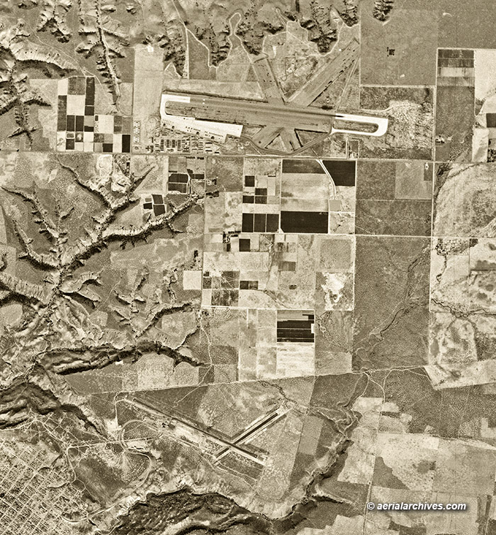
Image ID: AHLV4726
This 1955 historical aerial photograph of Brown Field and Tijuana International Airport shows both airports during important periods of their development. It is part of a collection of aerial photographs of Brown Field and Tijuana International Airport available from Aerial Archives.
Brown Field is one of the oldest airports in the United States, originally named East Field and opened in 1918 when the U.S. Army established an aerial gunnery and aerobatics school to relieve congestion at North Island. From 1918 and 1919 pilots trained in the Curtis JN-4D at East Field.
In 1943 the Navy changed the name of the airport to NAAS Otay Mesa. From 1943 through 1946 NAAS Otay Mesa was used to train pilots in the Lockheed P-38 Lightening, the Grumman F4 F Wildcat, the Grumman TBF/TBM Avenger and the Grumman F6F Hellcat.
The Navy turned the airport over to the City of San Diego in 1946. Chula Vista High School was established on the airfield with a temporary campus and an enrollment of 650 students in 1947.
The Navy reopened the airport as NALF Brown Field in 1951, and by the time this photograph was taken in 1955, Brown Field had been commissioned as a Naval Auxiliary Air Station to support fleet aircraft and field carrier landing practice. The F6F Hellcat, the F9F Cougar, the JD-1 Invader, the P2V Neptune and the FJ Fury were among the aircraft using the airport at this time.
In 1962 the airport was again transferred to the City of San Diego. Lufthansa moved its pilot training program from Phoenix to Brown Field in 1970 and still uses the airport for its training today.
Because Brown Field has a relatively long runway (Runway 08L/26R is 7972′ long), it is still used today by Navy C-130s and F/A-18s.
The Tijuana International Airport, seen at the bottom center of this photograph, is at the edge of the Mexican American border, just over one nautical mile south of Brown Field.
Tijuana Airport opened in 1951 and Mexicana de Aviacion began direct flights to and from Mexico City in 1954, one year before this aerial photograph was taken.
Mexico agreed to reorient the airport’s main runway from 10/28 to 09/27 to avoid airspace incursions into US airspace as part of its expansion. This reorientation increased the glide slope of the east approach, favored because the prevailing wind, above 3 degrees, preventing a full ILS approach because of a 2600′ obstacle, Cerro San Isidro. The expansion in 1970 included construction of a new terminal building. The old terminal became an air base for the Mexican Armed Forces.
Tijuana International Airport became a private concession in 1995, part of a total of 12 airports operated by Guadalajara based Grupo Aeroportuario del Pacífico (Pacific Airport Group), a consortium of Spanish investors.
The airport has continued to expand over time and now has a 23 gate main terminal with two concourses and one of the tallest control towers in Mexico. The Old Airport Terminal is still dedicated to military aviation.
In 2015, Tijuana International Airport opened the Cross Border Xpress (“CBX”), the world’s third cross-border passenger terminal. That terminal is located in the United States. A bridge connects it to the Tijuana International Airport.
For additional aerial photographs of Brown Field and Tijuana International Airport, please visit the links below, or, if you need additional imagery not shown on the site, please contact Aerial Archives directly.
License this photograph or purchase a print
More aerial photographs of airports
More aerial photographs of San Diego County
More aerial photographs of Tijuana
More historical aerial photographs of California