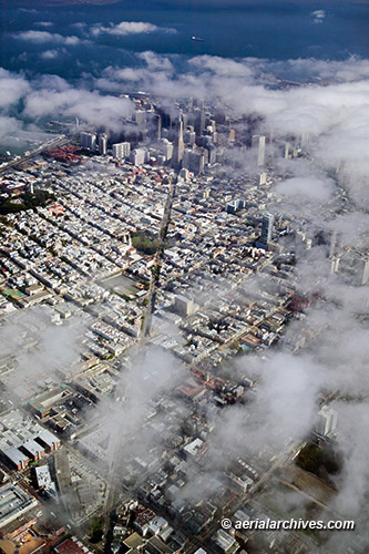
Aerial Photography South of Market SoMa San Francisco June 29, 2011 June 22, 2013 / By Herb Lingl / Aerial Photographs, Aerial Photography The San Francisco Museum of Modern Art (SFMOMA), designed by architect Mario Botta is in the center of this aerial photograph of San Francisco's South of Market Street (SoMa) district. To the right of the SFMOMA at 181 Third Street is the W San Francisco, a luxury boutique 33 story high rise hotel. In the foreground are the buildings of Yerba Buena Gardens that front Third Street. To the left of the San Francisco Museum of Art in this aerial photograph is the St. Regis Museum Tower, a five star hotel designed by Skidmore, Owings, and Merrill which includes 102 luxury condominiums and 269 hotel rooms. Image ID: AHLB8084 San Francisco, California © Herb Lingl/aerialarchives.com More aerial photography of San Francisco More aerial photography of San Francisco’s SoMa District
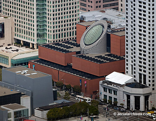
Aerial Photography San Francisco | Fog June 16, 2011 June 22, 2013 / By Herb Lingl / Aerial Photographs Fog rolling in over San Francisco ensures constantly and rapidly changing aerial views of the city. This aerial photograph shows the patches of fog at the leading edge of the bank moving in over San Francisco in the early afternoon. Some patches of fog already obscure parts of North Beach and much of San Francisco's financial district, though Coit Tower and some of the Embarcadero and Transamerica pyramid are still visible in this aerial perspective looking down Columbus Avenue. Image ID: AHLB3171 San Francisco, California © Herb Lingl/aerialarchives.com More aerial photography of San Francisco More aerial photography of San Francisco in the fog
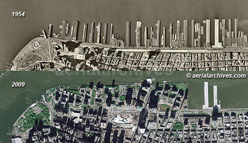
Historical Aerial Photography: Then and Now Comparisons | Manhattan June 8, 2011 June 22, 2013 / By Herb Lingl / Aerial Photographs, Historical Aerial Photography The Hudson river shoreline of Manhattan changed dramatically during the last five decades. The two historical aerial photographs illustrate the amount of change that has occurred at this portion of Manhattan between 1954 and 2009. As the 1954 historical aerial photograph shows, the piers along the Hudson river were still actively used at that time. Eventually, shipping activity shifted to the New Jersey side of the Hudson river. In 1973 what were once Piers 1 through 21 were buried under landfill from the World Trade Center construction project and became Battery Park City. The ongoing construction of the new World Trade Center buildings ensures that this portion of Manhattan will continue to change significantly in the near term. Manhattan, New York City 1954-2009 Image ID: AHLV3409 More historical aerial photography then and now comparisons.
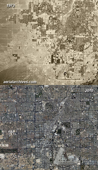
Historical Aerial Photography of Las Vegas June 2, 2011 June 22, 2013 / By Herb Lingl / Historical Aerial Photography These two historical aerial photographs show how much Las Vegas, Nevada has changed during several decades of very rapid growth, multiplying its size several fold during those years. The historical aerial photograph on the top was acquired in 1973 and the aerial on the bottom is a mosaic of photographs acquired in 2010. The city has expanded into the adjacent desert with particularly strong growth in the western portion of the city. High resolution aerial photography of sections of the city also show on a more detailed scale how rapidly certain portions of Las Vegas have changed during very short periods of time. Particularly dramatic are the changes during the 1990s in the northwestern portion of the city. Las Vegas, Clark County, Nevada 1973-2010 Image ID: AHLV3391 More historical aerial photography of Las Vegas.