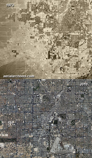
Historical Aerial Photography of Las Vegas June 2, 2011 June 22, 2013 / By Herb Lingl / Historical Aerial Photography These two historical aerial photographs show how much Las Vegas, Nevada has changed during several decades of very rapid growth, multiplying its size several fold during those years. The historical aerial photograph on the top was acquired in 1973 and the aerial on the bottom is a mosaic of photographs acquired in 2010. The city has expanded into the adjacent desert with particularly strong growth in the western portion of the city. High resolution aerial photography of sections of the city also show on a more detailed scale how rapidly certain portions of Las Vegas have changed during very short periods of time. Particularly dramatic are the changes during the 1990s in the northwestern portion of the city. Las Vegas, Clark County, Nevada 1973-2010 Image ID: AHLV3391 More historical aerial photography of Las Vegas.
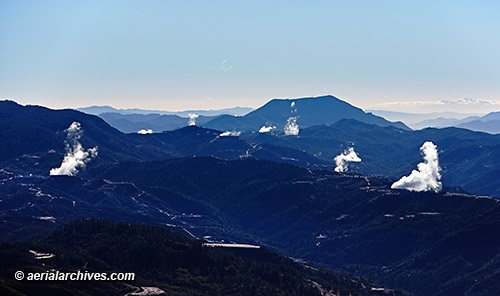
Aerial Photography of Geothermal Power Plants May 25, 2011 June 22, 2013 / By Herb Lingl / Aerial Photography Steam rises from numerous geothermal power plants which are part of the Geysers complex, the largest geothermal complex in the world. Twenty two geothermal power plants draw steam from more than 350 wells. Seismic and gravity studies indicate that the source of the heat for the geothermal power plants is a magma chamber over 8 miles in diameter and 4 miles underground. Calpine Corporation owns and operates 19 of the active geothermal power plants. Electrical production from the Geysers geothermal power plants peaked in 1987 and has declined since then as the underground water source gradually declines. Research and development of new geothermal power technologies called enhanced geothermal systems do not require convective hydrothermal resources and are expected to increase power output from the Geysers geothermal complex in the future. Mayacamas Mountains Lake and Sonoma Counties, California Image ID: AHLB8018 © Herb Lingl/aerialarchives.com More aerial photography of geothermal power plants.
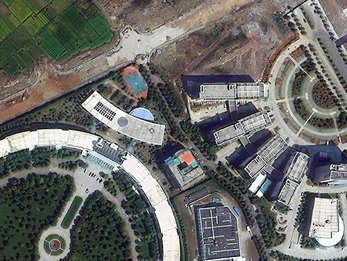
High Resolution Satellite Imagery of China May 18, 2011 June 22, 2013 / By Herb Lingl / Satellite Imagery This high resolution satellite image documents the edge of development in Ningbo, one of China's oldest cities. While it has an ancient history, Ningbo's economy is growing rapidly. High resolution satellite imagery is proving to be an exceptionally useful tool in China, because of its vast size, the rapid changes taking place and the more limited availability of airborne imaging. Atmospheric visibility issues can further stretch out the time frames for projects relying on acquiring new imagery. That's why an archive of existing, high resolution, cloud free, recent satellite imagery of China can be invaluable. Aerial Archives provides its US clients access to DigitalGlobe's large archive of high resolution satellite imagery of China which includes recent imagery of over 150 of China's largest cities. Ningbo, Zhejiang, China Image ID: AHLS2010 More about high resolution satellite imagery of China
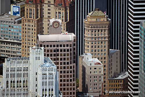
Aerial Photography of San Francisco Architecture May 10, 2011 June 22, 2013 / By Herb Lingl / Aerial Photographs Many different styles of San Francisco architecture are shown in this aerial photograph of a portion of the financial district. At the left in the foreground is 140 New Montgomery Street, San Francisco's first skyscraper. Built in the art deco architectural style, 140 New Montgomery served as an office building for over 80 years until it was converted into residential condominiums. Directly behind 140 New Montgomery is 33 New Montgomery Street, a 20 story high rise office building designed in the post-modern architectural style. The building wraps around the Bank of America Building at 623 Market Street, which is not as tall and not visible in this aerial photograph. Prominent features of 33 New Montgomery Street are the large clock tower and spike at the top of the building. Directly behind 33 New Montgomery Street is the Hunter-Dulin Building, located at 111 Sutter Street. Built in a Renaissance revival architectural style, this 308 foot high rise is San Francisco's only building with Romanesque and French Chateau ornamentation. Directly to the right of 33 New Montgomery Street in this aerial photograph is the Hobart Building designed by John Willis, San Francisco's leading architect during the rebuilding of San Francisco after the 1906 earthquake and fire. Designed in the beaux-arts classical revival architectural style with Renaissance/Baroque ornamentation, the building was completed in less than one year. Serving as a background to the Hobart building is 44 Montgomery Street, a modernist 43 floor high rise designed by architects John Graham and Associates. To the right of 44 Montgomery Street is 595 Market Street, another skyscraper designed in the modernist architectural style by Skidmore, Owings and Merrill. Just a very small portion of the post modern style KPMG Building, 55 Second Street, is visible on the far right portion of the frame of this aerial photograph. San Francisco Image ID: AHLB5490 © Herb Lingl/aerialarchives.com More aerial photography of San Francisco architecture More aerial photography of San Francisco’s financial district Search aerial photography of San Francisco architecture
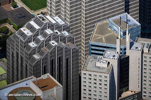
Aerial Photography of San Francisco Skyscrapers May 4, 2011 June 22, 2013 / By Herb Lingl / Aerial Photographs Aerial photograph of the tops of several San Francisco skyscrapers in the heart of the financial district. This aerial photograph created with a very long lens shows a unique perspective on these office towers which are relatively close to each other but actually have quite different heights. The aerial shows two buildings of the Embarcadero Center complex (a five office tower and two hotel commercial complex designed by John Portman and Associates): Embarcadero West (275 Battery Street)(left center), 34 stories and 404 feet tall and One Embarcadero Center (background), 45 stories and 569 feet tall. Also shown in this aerial photograph is the rooftop of 353 Sacramento Street (the office tower with the tinted wall middle right) designed by Skidmore, Owings & Merrill (SOM) and the top of 345 California Center (right front) a 48 story, 695 foot office tower also designed by SOM. San Francisco, California Image ID: AHLB4631 © Herb Lingl/aerialarchives.com More aerial photography of skyscrapers More aerial photography of San Francisco skyscrapers
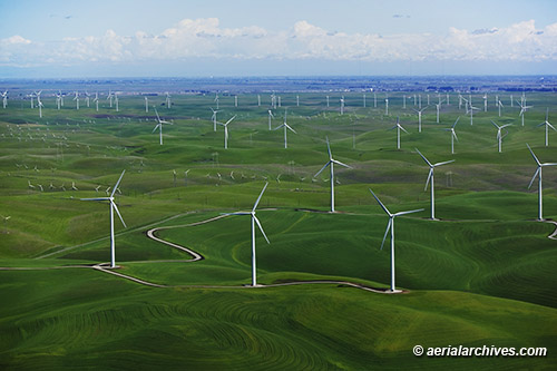
Aerial Photography of Wind Power, Wind Turbines and Wind Farming April 27, 2011 June 22, 2013 / By Herb Lingl / Aerial Photography Aerial photograph of the Shiloh Wind Power Plant in northern California. Over 150 large wind turbines with towers up to 262 feet tall are part of this large wind farm which supplies energy to Pacific Gas and Electric, the Modesto Irrigation District and the City of Palo Alto. The wind farm was built in two stages, the first phase consisted of 100 General Electric 1.5 MW wind turbines. The second phase added another 75 2MW wind turbines. The 6800 acres of land on which the wind turbines are located is leased from land owners who continue to use it for grazing and growing hay. Shiloh Wind Power Plant Montezuma Hills, Solano County, California Image ID: AHLB7459 © Herb Lingl/aerialarchives.com More aerial photography of wind power, wind turbines and wind farms.
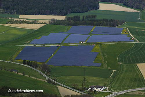
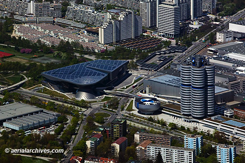
Aerial Photography of Solar Farming in Bavaria, Germany April 20, 2011 June 22, 2013 / By Herb Lingl / Aerial Photography Aerial photograph of several fields of solar panels surrounded by agricultural fields in Bavaria between Munich and Augsburg, Germany. The Bavarian countryside has a remarkable density of solar installations, in fields, on warehouse rooftops and on the rooftops of residences in villages. Image ID: AHLB7595 © Herb Lingl/aerialarchives.com The large flat rooftop in left center of this aerial photograph covers BMW’s Lifestyle Shop, part of BMW’s headquarters in Munich. The roof is covered with solar panels–urban Bavarian solar farming. Munich, Bavaria, Germany. Image ID: AHLB7591 © Herb Lingl/aerialarchives.com More aerial photography of solar installations
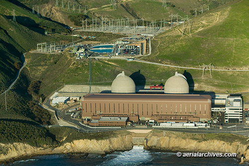
Aerial Photograph of Diablo Canyon Nuclear Power Plant April 14, 2011 June 22, 2013 / By Herb Lingl / Aerial Photography Aerial photograph of Diablo Canyon Nuclear Power Plant which uses seawater from the Pacific Ocean for cooling and is constructed directly over one fault line and near a second one. PG&E's application to relicense the Diablo Canyon plant is currently being scrutinized in response to growing concern arising from Japan's Fukushima Daiichi nuclear power plant disaster. The plant was upgraded to withstand a magnitude 7.5 earthquake after the discovery of the nearby Hosgri fault which generated a 7.1 magnitude earthquake in 1927. This aerial photograph shows the containment spheres for the two Westinghouse designed pressurized water nuclear reactors. Issues concerning the use of seawater for cooling include the possible ingestion of kelp (the plant is throttled back during storms to mitigate this problem) and the possible ingestion of sea life (in 2008 one of the two units was taken off line because of a rapid influx of jellyfish at the water intake). Water used for cooling can be seen returning to the Pacific Ocean in the bottom of this aerial view. The plant has been the subject to several legal challenges and protests, and in 1981 1900 activists were arrested at the plant during two weeks--the the largest number of arrests in the history of the United States anti nuclear movement. The nuclear power plant is located at Avila Beach, San Luis Obisopo County, California. Image ID: AHLB4674 More aerial photography of nuclear power plants