San Francisco Giants Opening Day, April 11, 2000 Poster November 3, 2014 November 3, 2014 / By admin / Aerial Photographs, Aerial Photography, Events, Historical Aerial Photography This 22 x 28 inch aerial poster of San Francisco is a view created on Opening Day, April 11, 2000 at San Francisco's baseball stadium, ATT park, also once known as SBC park and PacBell park, home of the San Francisco Giants. San Francisco Giants' baseball park in San Francisco is the first privately financed stadium in major league baseball since Dodger Stadium in 1962. With a seating capacity of 41,503 the park has a unique setting at the edge of San Francisco bay, with outstanding seats--the first row of seats is only 48 feet from homeplate. The Goodyear blimp was flying and broadcasting overhead on this day. The poster also shows a containership emerging from the fog entering San Francisco bay beneath the Golden Gate bridge, an audience of boats in McCovey Cove adjacent to the ballpark, and provides an excellent view of San Francisco's South Beach marina. Image ID: AHLE0114 © Herb Lingl/aerialarchives.com Purchase this poster The official site of the San Francisco Giants
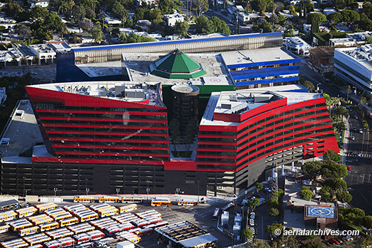
Aerial-Photography-of-Los-Angeles October 3, 2014 October 3, 2014 / By Herb Lingl / Aerial Photographs, Aerial Photography This aerial photograph shows the Center Red, the 450,000 square feet third phase of the Pacific Design Center. The Pacific Design Center is a 1,200,000 square feet multi-use facility for the design community located in West Hollywood. Designed by Cesar Pelli, the 14 acre campus opened in 1975. Center Red sits on top of seven levels of parking which can accommodate 1500 cars. The Pacific Design Center houses a branch of the Museum of Contemporary Art and the west coast's top decorating and furniture market. Image ID: AHLE0110 © Herb Lingl/aerialarchives.com License or purchase a print of this aerial photograph More aerial photographs of Los Angeles California Historical aerial photographs of Los Angeles Pacific Design Center website
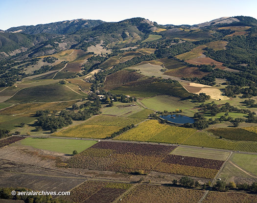
Aerial Archives and the current Sonoma County Crop Report July 2, 2014 July 2, 2014 / By Herb Lingl / Aerial Photographs, Aerial Photography This aerial photograph of the vineyards in the Sonoma Valley and on the slopes of the Mayacamas Mountains in the fall was featured on the cover of this year's Sonoma County crop report. The report outlines the current state of Sonoma County agriculture. The report indicates that 2013 rainfall was the lowest recorded in Sonoma County history in the last 120 years. Heavy rains in Nov and Dec of 2012 mitigated the impact of the dry 2013 conditions somewhat and the total dollar value of Sonoma County's agricultural output increased by 4%. The report confirmed that 2013 provided an excellent growing season for winegrapes, resulting in high quality and quantity. More than 270,000 tons of winegrapes valued at over $600 million were processed, which represents the largest winegrape harvest in Sonoma County history. Image ID: AHLB4263 © Herb Lingl/aerialarchives.com More information about the Sonoma County Crop Report More aerial photographs of Sonoma County, California More aerial photographs of vineyards
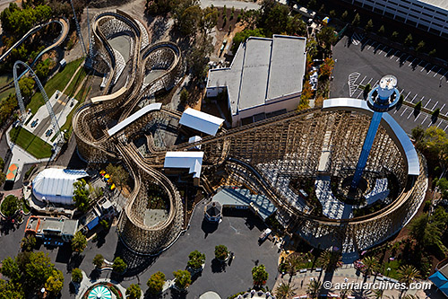
Aerial Photography of California’s Great America December 3, 2013 December 3, 2013 / By Herb Lingl / Aerial Photographs, Aerial Photography This aerial photograph of California's Great America amusement park in Santa Clara shows the Gold Striker wooden rollercoaster, which was added to the park this year, together with the Star Tower at the right and Xtreme Skyflyer at the left. The park, originally constructed by Marriott, opened in 1976. Since then it has had numerous owners including the City of Santa Clara, Kings Entertainment Company, Paramount Parks and Cedar Fair Entertainment Company, the current owner. The new San Francisco 49ners stadium is currently under construction adjacent to California's Great America. Image ID: AHLE0048 © Herb Lingl/aerialarchives.com More aerial photographs of California’s Great America More aerial photographs of Santa Clara, California More aerial photographs of San Jose, California
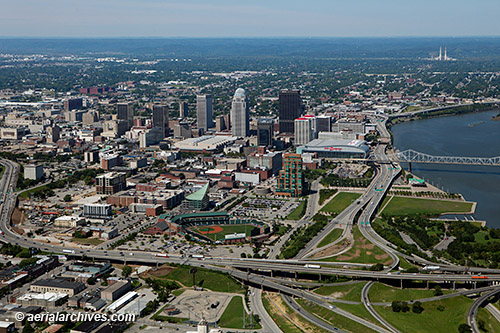
Aerial Photography of Louisville, Kentucky September 8, 2013 September 8, 2013 / By Herb Lingl / Aerial Photographs, Aerial Photography This aerial photograph of Louisville, Kentucky shows the Louisville Extreme Park and a portion of the East Market district in the foreground together with the interchange of the I-64, I-65 and I-71 freeways. The Riverwalk and the Louisville Slugger Stadium are visible directly behind these features. In the middle ground is the downtown Louisville skyline including the Clark Memorial bridge, the KFC Yum! Center, the PNC Plaza, the AEGON Center and the Louisville International Convention Center. The chimneys of the R. Gallagher Generating Station, a coal burning power plant located on the other side of the Ohio river, in New Albany, Indiana are visible in the background. Image ID: AHLB9902 © Herb Lingl/aerialarchives.com More information about aerial photography of Louisville, Kentucky Gallery of aerial photography of Louisville, Kentucky
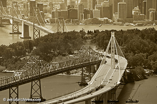
Aerial Photographs of the New Eastern Span of the Bay Bridge August 31, 2013 August 31, 2013 / By Herb Lingl / Aerial Photographs, Aerial Photography Final construction necessary to place the new eastern span of the Bay Bridge into service is underway in this aerial photograph created August 30, which shows the new eastern span tower, the old cantilevered span, and in the left background the western suspension span of the Bay Bridge. Dust is visible at Yerba Buena island where work is taking place to connect the eastern span to the tunnel passing through Yerba Buena. San Francisco's downtown waterfront is visible in the background. Image ID: AHLB9849 © Herb Lingl/aerialarchives.com More aerial photography of the San Francisco Oakland Bay Bridge Information about San Francisco Oakland Bay Bridge aerial photography The latest from Caltrans about the San Francisco Oakland Bay Bridge
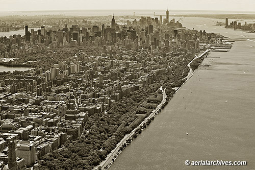
Aerial Photography of Riverside Park Manhattan August 22, 2013 August 22, 2013 / By Herb Lingl / Aerial Photographs, Aerial Photography This aerial photograph of the Manhattan skyline shows Riverside Park, the Hudson River, West Side Drive and the Upper West Side in the foreground. A portion of Central Park and mid town are visible in the background as are One World Trade Center (Freedom Tower), the Empire State building, Brooklyn, Jersey City and the Verrazano-Narrows Bridge. Image ID: AHLB9843 © Herb Lingl/aerialarchives.com Search for aerial photography of New York City More aerial photography of New York City Historical aerials of New York City
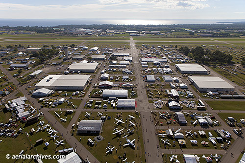
Aerial Photography EAA AirVenture 2013 Oshkosh August 16, 2013 August 17, 2013 / By Herb Lingl / Aerial Photographs, Aerial Photography, Events Aerial Archives created a series of aerial photographs of the Experimental Aircraft Association’s AirVenture 2013 Oshkosh, the largest gathering in the world of aviation enthusiasts on the morning of August 1. This view faces east toward Lake Winnebago and runways 18-36 left and right of the Whittman Regional Airport (KOSH). In the foreground on the right is the display of Cessna Aircraft Company. In the middle ground on the left are the exhibit hangars of Aircraft Spruce & Specialty and Rockwell Collins. In the middle ground on the right are the exhibit hangars of Bendix King by Honeywell and Garmin. Beyond the exhibit hangar of Aircraft Spruce & Specialty toward the runways is the FAA control tower, the busiest control tower in the world during the event. The FAA has staffed a tower at the EAA convention since the 1960s. FAA controllers compete to work the event which is known among controllers as the “Super Bowl” of air traffic control. More than 10,000 airplanes arrive for the event. Many thanks to Don Voland of Aero Optics, Inc and Nick Anderson, the pilot who flew the Bell-47 helicopter from which these aerial photographs were created. Image ID: AHLB9831 © Herb Lingl/aerialarchives.com More aerial photography of AirVenture 2013, Oshkosh, Wisconsin Aerial photography of Oshkosh, Wisconsin More information about the Experimental Aircraft Association and AirVenture
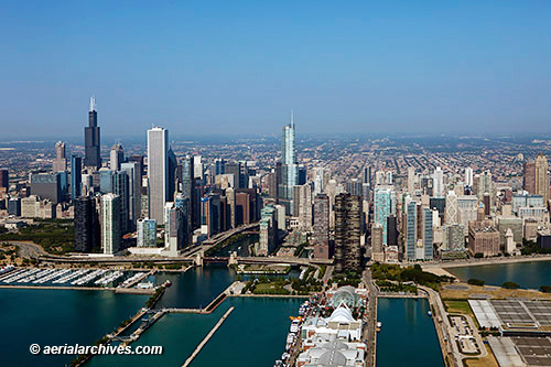
Aerial Photography Chicago January 10, 2013 June 22, 2013 / By Herb Lingl / Aerial Photographs, Aerial Photography This aerial photograph of the Chicago skyline from Lake Michigan shows the Navy Pier in the foreground, the Willis Tower and a portion of Millenium Park on the left and the Chicago river and Trump Tower toward the center of the photograph. Image ID: AHLB9385 © Herb Lingl/aerialarchives.com More aerial photography of Chicago, Illinois More information about aerial photography of Chicago, Illinois
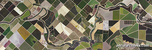
Aerial Archives Murals on Display at East Bay Regional Park District’s Big Break Visitor Center July 11, 2012 June 22, 2013 / By Herb Lingl / Aerial Photographs, Aerial Photography Two large aerial photography murals of the Sacramento River Delta are part of a new exhibit at the Big Break Visitor Center in Oakley, California. The exhibit, designed by Nick Cavagnaro and Doyle Wegner of the East Bay Regional Park District with assistance of Frank Binney and Associates, provides insight into the Delta’s geography, history and uses. Three fourths of Delta lands are used for agricultural purposes as illustrated in this aerial photograph. Because of the Delta’s fertile peat soils and controlled marine influence, it produces a yield per acre that is almost 50% higher than California’s average. Image ID: AHLV3553 © aerialarchives.com More aerial photography of the Sacramento San Joaquin river delta More information about aerial photography of the Delta More information about the East Bay Regional Park District’s Big Break Regional Shoreline