
DataDoors Desktop Simplifies Creating Custom Aerial Maps
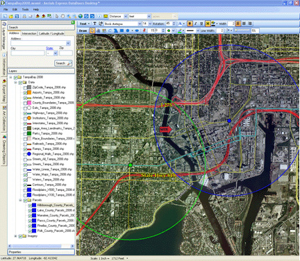
Screen Shot of the
DataDoors Desktop Application
© Aerials Express
Terms of Image Use | Feedback
The DataDoors Desktop software solution provides clients the ability to create and publish professional grade aerial maps from aerial photography. The software provides an elegant interface to access seamless high resolution imagery and to leverage the use of that imagery throughout the clients' enterprise. Users can quickly incorporate current, high resolution imagery directly into customized map layouts and can view, illustrate, and annotate professional maps for marketing, site selection, research, engineering and planning projects any desktop or notebook computer. DataDoors Desktop software enables clients to export high resolution imagery to scale, to import company logos and custom graphics and to make professional prints. The software incorporates easy to use drawing and text tools, a measuring tool and address search capability and the maps the user creates can be emailed directly from the application. DataDoors Desktop supports numerous file formats including ECW (.ecw) ,Shape Files (.shp), GeoTiff (.tif), Tiff, World File (.tfw), Mr.Sid (.sid), JPEG 2000 (.jp2). Joint Photographic Experts Group (.jpg), Portable Network Graphics (.png) and Graphic Interchange Format (.gif). To schedule a demonstration of DataDoors Desktop or receive a video of how DataDoors Desktop functions, please contact Aerial Archives.
|